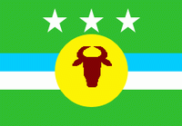
Rosario de Perijá (Municipio Rosario de Perijá)
 |
 |
The local economy is based primarily on cattle raising. There is also an important exploitation of limestone for the cement industry.
The majority of the population is made up of average mixed-race Venezuelans, but there are Native American communities in the Western and Northern parts: Yukpa and Wayuu Indians. There is also a small community of Japrería Indians.
There has been a serious conflict for several decades between the Native American population and the cattle ranchers for the use of the lands.
Map - Rosario de Perijá (Municipio Rosario de Perijá)
Map


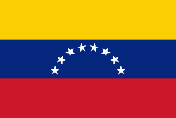
Country - Venezuela

Currency / Language
| ISO | Currency | Symbol | Significant figures |
|---|---|---|---|
| VES | Venezuelan bolÃvar | BsS. or Bs. | 2 |
| ISO | Language |
|---|---|
| ES | Spanish language |